
Even a child knows that poles are the points at the Earth’s very top and very bottom. The thing is, though, that the Earth is spherical and spheres, by definition, do not have tops or bottoms. Besides, a closer inspection makes it quite clear that there are no fewer than nine different poles scattered about our planet’s polar regions. It seems, therefore, that the common definition of the pole could do with some refining.
DEFAULT POLES
The Earth in its cosmic voyage travels not only around the Sun, but also – like a gigantic spinning top – around its own axis. As early as 3000 years BC, enthusiasts of the night sky, with the ancient Greek scholars at the lead, noticed that the stars revolved above their heads in a rather orderly manner, which is to say, around a single point located near the constellation of the Little Bear (Ursa Minor). Over time, through careful observation and meticulous calculations, they came up with the concept of the geographic coordinate system, according to which the Earth’s points of rotation, or points at which the Earth’s imaginary axis goes through its surface, lie exactly at 90° latitude north and south, at the spot where all lines of longitude converge. And that’s how the first and so far the most famous pair of poles – the Earth’s geographic poles – entered the picture.
Bearing in mind that the poles have officially been around for over two millennia, you might assume that they no longer hold any mysteries for scientists. And yet they do. At the end of the 19th century, it turned out that the Earth wobbles ever so slightly in its spin, much like an unbalanced wheel with a faulty bearing. Although this persistent wobble (known as the Chandler wobble) has been observed on many planets, which – just like Planet Earth – are not perfectly spherical, it is still unclear where it comes from and why it does not disappear on its own. What is clear by now is that, as a result of this phenomenon, the actual (instantaneous) north pole pirouettes in 14-month cycles, drawing spirals of up several metres across.
It seems, therefore, that the Earth’s geographic poles are not places in the classical sense of the word, but rather abstract mathematic constructs developed for the purposes of cartography and scientific modelling. Nevertheless, for years they both featured prominently on personal travel lists of countless cold-loving adventurers.

The geographic north pole has been regularly visited by commercial expeditions for about 30 years. An additional attraction for this particular group is their means of transport, as 50 лет Победы is one of the largest icebreakers in the world.
© Christopher Michel (CC BY 2.0)
UNRULY POLES
But the geographic poles do not exhaust the subject. Those of us who occasionally make use of a traditional pocket compass, rely in the process on an altogether different set of poles, because – even though compasses help us determine geographic directions – the poles they point to are in fact the magnetic poles. The distinction was first recognized at the end of the 11th century in China, which might have had something to do with the fact that the Chinese, as the inventors of the magnetic compass, were at the time its most experienced users. And because, when it comes to magnets, it’s the opposites that attract, the northern tip of the compass needle, or its northern pole, points to the magnetic… south pole, which happens to be located in the geographic north. Luckily, scientists have unanimously agreed that using physical terms in geography causes such confusion that, for convenience’s sake, the Earth’s magnetic poles should be labelled according to their location rather than physical properties. In other words, in discussions like our present one the magnetic pole located in the northern hemisphere is referred to as the north magnetic pole, and the one in the southern hemisphere – as the south magnetic pole. With the issue of terminology out of the way, let us now try to figure out what magnetic poles really are and where exactly we should look for them.
The Earth’s magnetic field, and consequently – the existence of the Earth’s magnetic poles, is most probably a side effect of convection currents swirling inside the Earth’s liquid outer core. Because the currents are heavily influenced by the planet’s rotation, the magnetic poles, which is to say, points where the lines of the Earth’s magnetic field are perpendicular to the planet’s surface, are located close to the geographic poles. But only roughly so. And only occasionally. Since 1831, when the location of the north magnetic pole was first determined by the British polar explorer James Clark Ross, the pole has travelled over 2000 km. It currently sits about 450 km south of its geographic counterpart, but the distance between the two is getting shorter, as the magnetic pole creeps towards Siberia at a rate of about 55 km per year. To make matters even more complicated, the south magnetic pole, which most of us would expect to find on the exact opposite side of the globe, could not care less about popular expectations and is currently wandering approximately 20 degrees closer to the equator than the magnetic north pole. Come to think of it, however, one can hardly expect stability and symmetry from a magnetic field generated by spluttering masses of molten rock sloshing about deep inside the Earth.
What’s worth noting, is that the magnetic poles, unruly though they may seem, are currently quite well-behaved and their contemporary travels are a mere trifle compared to what they’re capable of. This is because once in a while the magnetic poles go crazy and swap locations. The magnetic reversal, which is what the phenomenon is called, occurs on average every quarter million years (although it’s been over three times as long since the last one) and – contrary to what many tend to think – it is not a sudden flip, but an arduous journey lasting between 1000 and 10 000 years. Throughout this time, the Earth’s magnetic field writhes and wriggles, strengthens and fades, causing a multitude of extra magnetic poles to pop up at the most unexpected latitudes. And although this upheaval appears to have no impact on living organisms, it might seriously affect modern technology many of them rely on in their daily lives.
AVERAGED POLES
Because the fickle nature of the Earth’s actual magnetic field is a constant headache for scientists, an attempt was made to try and find out what would happen if the Earth’s liquid outer core was replaced with a simple (albeit massive) bar magnet, similar to those used in school experiments. As a result, the four poles described above were joined by yet another couple located in still different places. The new additions are the geomagnetic poles, which – unlike the actual magnetic poles – are synchronized and thus occupy the exact opposite sides of the planet. In other words, they always lie at the same latitude and the sum of their longitude invariably equals 180 degrees. The geomagnetic poles, of which the northern is currently located on Canada’s Ellesmere Island and the southern – near the Russian Vostok Research Station in Antarctica, are part of a general, averaged model of the Earth’s magnetic field, which is tilted just under 10 degrees relative to the Earth’s axis of rotation and extends far into space, where it forms a protective shield known as the magnetosphere. The Earth’s magnetosphere protects the atmosphere (and consequently us) from harmful cosmic radiation and solar wind, treating the residents of the Earth’s polar regions to magnificent spectacles in the form of auroras. And although auroras can sometimes be observed at relatively low latitudes, their frequency and intensity is the greatest in the so-called auroral zones, which stretch around the Earth’s geomagnetic poles.
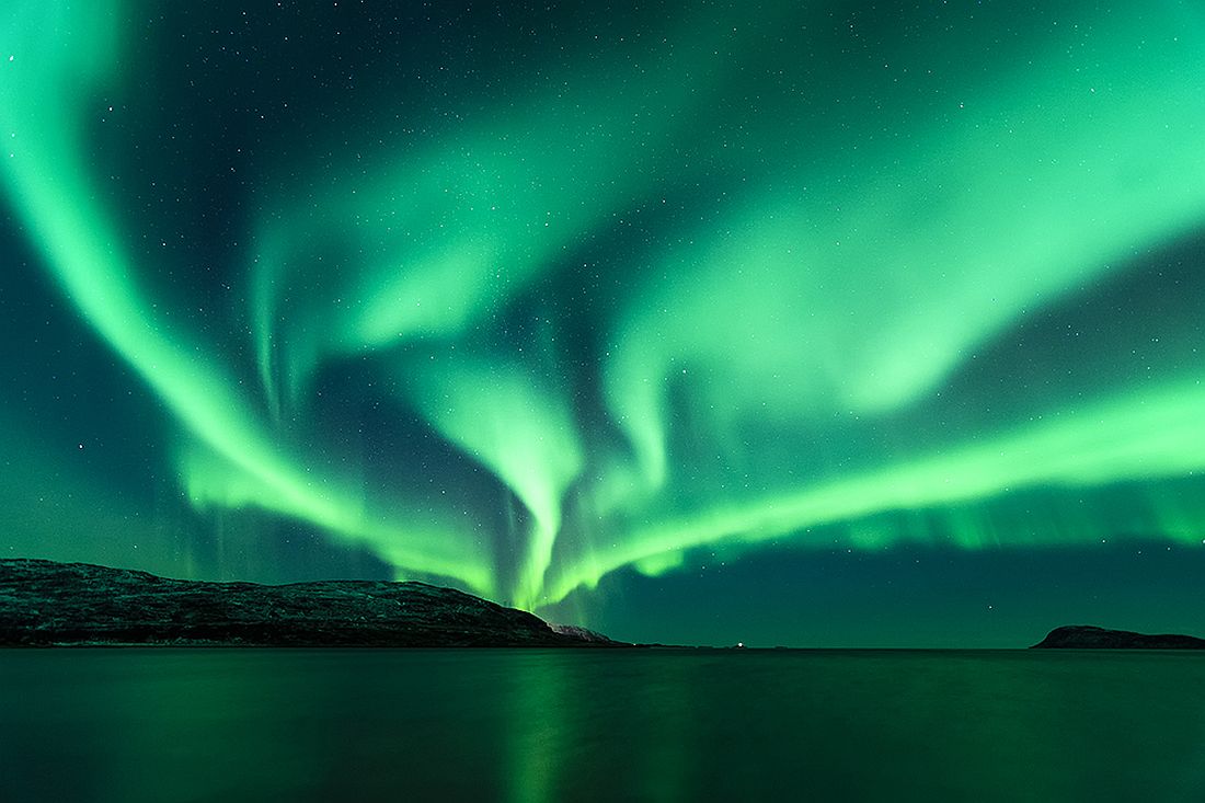
Admired from the ground, an aurora may seem to light up the whole sky.
© Roman Popelar (CC BY-NC-SA 2.0)

When seen from space, northern and southern lights form clear rings around the Earth’s geomagnetic poles.
Image captured by a NASA satellite (CC0 public domain)
SECLUDED POLES
Even though none of the above-mentioned poles enjoys a convenient location, in 1920 Vilhjálmur Stefánsson, who went down in history as a distinguished (although somewhat controversial) explorer of the Arctic, introduced the concept of the pole of inaccessibility, which – in his opinion – was to draw attention to the fact that, from a practical point of view, the geographic north pole was not (and still isn’t) the point in the Arctic most challenging to reach on foot. To meet the criterion of maximum inaccessibility, a place had to lie at a greatest possible distance from the nearest coastline, seen as a potential point of access. With much of the high Arctic being a frozen ocean, the pole of inaccessibility was surely somewhere on the pack ice. But where? To find it, Stefánsson – inspired by a paper published by the outstanding Russian polar navigator Admiral Alexander Kolchak – drew circles on the map of the Arctic Ocean so that their outlines touched, but did not cross the coastline. The north pole of inaccessibility is the very centre of the largest of such circles, a literal middle of nowhere. About a hundred years later, in the second decade of the 21st century, the original coordinates of the spot were subjected to a scientific verification, which revealed that the generally accepted location of the north pole of inaccessibility was in fact incorrect. The error had probably stemmed from the insufficient accuracy of contemporary cartographic data, as the adopted methodology means the calculation results are only as accurate as the representation of the shoreline on the chart, and getting this right for the region of the high Arctic was until recently a serious challenge. Nowadays, the accepted position of the north pole of inaccessibility is 85°48′N, 176°09′E, over 200 km from the point suggested by Stefánsson and a whopping 1008 km from the nearest land mass. It’s worth stressing, however, that in this particular case land is not quite a synonym of safety, because each of three equidistant coasts belongs to an inhospitable Arctic island, of which only Ellesmere Island is populated, albeit sparsely.
The first enthusiasts of the new north pole might have messed up their calculations, but their assumptions regarding the pole’s inaccessibility turned out to be perfectly correct. And so, because of challenges involved in pinpointing a featureless location on the surface of ever-shifting pack ice, while having at one’s disposal only traditional navigational instruments, inaccurate maps and – most importantly – wrong coordinates (in the past) as well as deteriorating ice conditions in the Arctic Ocean (in the present), the north pole of inaccessibility is yet to be conquered.
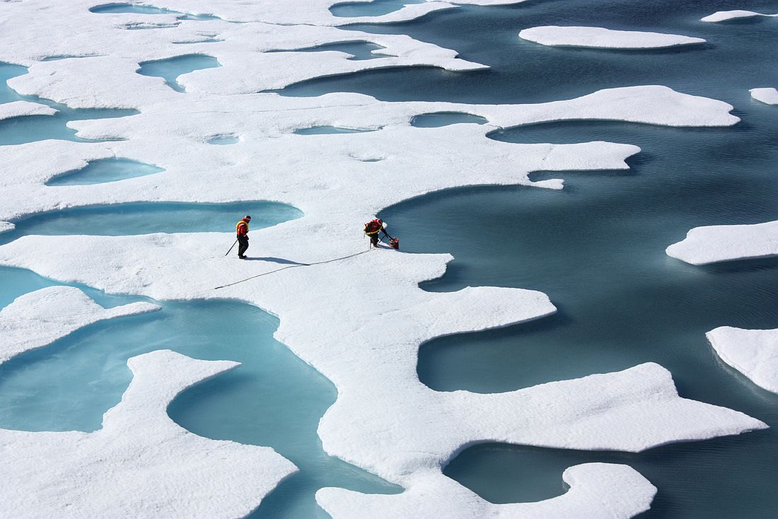
Due to the melting of sea ice in the Arctic Ocean, it is becoming more and more risky to travel in the area on foot.
© Kathryn Hansen, NASA (CC BY 2.0)
And how are things in the far south? Even though Stefánsson in his deliberations did not venture outside the Arctic, the concept of the pole of inaccessibility was soon adapted to Antarctic conditions. Finding the pole, however, once again proved anything but easy. As we already know, the pole of inaccessibility is a place located at a maximum possible distance from the nearest coast. In the Arctic, the coast was the edge of the nearest land, in the Antarctic – the edge of the ocean. The problem is that the term can be interpreted in two different ways: as the actual edge of the continent, hidden deep under the ice sheet (inner coastline) or as the edge of Antarctica’s floating ice shelves, which – due to the increased intensity of glacier calving – is currently subject to continuous, often dramatic changes (outer coastline). For this reason, two poles of inaccessibility have been defined in Antarctica – the inner and the outer.
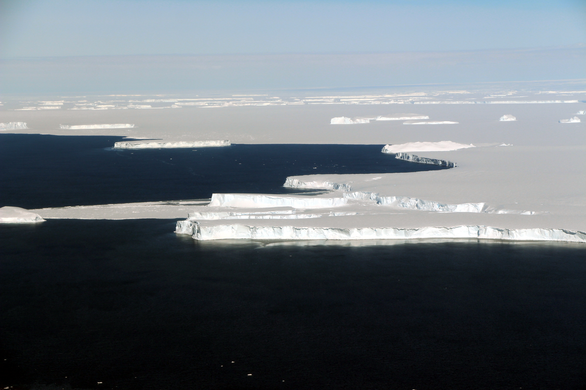
The outer coastline of Antarctica is marked by the edge of its ice shelves, which nowadays undergo very dynamic changes.
© NASA (CC BY 2.0)
Due to the developments in ground-penetrating radar technology, which makes it possible for scientists to see through Antarctica’s ice, working out the exact whereabouts of the edge of the seventh continent, and – by the same token – the inner south pole of inaccessibility, is getting easier and easier. According to the most recent data published by a team of researchers from the Scott Polar Research Institute, British Antarctic Survey and the University of California, Berkeley, the pole sits at 83°37’S, 53°43’E, at a distance of 1180 km from the edge of Antarctica’s land mass and about 75 km from the location established a decade earlier. The difference might probably be accounted for by improvements in mapping technology. What’s interesting, however, is that a preference for this or that location has more to do with the circumstances than the accuracy with which it was determined. And so, in the context of competitive sports (to avoid confusion in the ranking, perhaps), the official location of the south pole of inaccessibility is still 82°06’S, 54°58’E, where the most relentless adventurers are greeted by a windswept… bust of Vladimir Lenin. It’s a remnant of a Soviet research station, set up at the end of 1958 (presumably as a piece of Cold War bravado), whose original name – Полюс недоступности – is Russian for the pole of inaccessibility. Even though the station never occupied the exact spot determined by relevant calculations and was largely abandoned after a mere few weeks, it is still treated as an embodiment of the concept of maximum inaccessibility and few adventurers express any doubt as to its actual location.
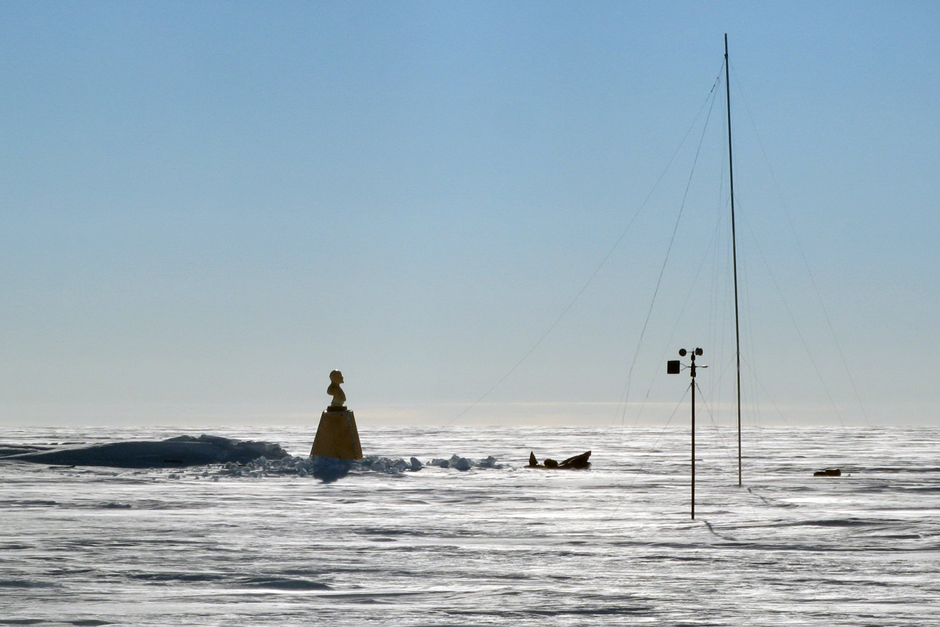
The bust of Vladimir Lenin rising above the ice of Antarctica acts like a magnet for hard-core polar adventurers.
© Henry Cookson at English Wikipedia (CC BY-SA 1.0)
There still is, however, much doubt as to the position of the outer south pole of inaccessibility, and the points suggested over the years are scattered within a radius of many hundred kilometres. The reason behind the confusion, however, is not so much the contrary nature of scientists, but dynamic changes which – with the climate change upon us – occur within the ice shelves of Antarctica. As claimed by the already mentioned team of scientists, since the beginning of the 21st century, the outer south pole of inaccessibility was shifting its position at a rate of about 1 km a year, as a result of which in 2019 it lay at 83°54’S, 64°53’E, nearly 1600 km from the edge of the ocean. But when it seemed that the topic could be put aside for a while, Antarctica’s glaciers calved a monstrous iceberg measuring 1600 km2 (D-28), followed two years later by another giant, nearly three times the size (A-76), and in spring 2022 the entire Conger ice shelf, with the surface area of 1200 km2, completely disintegrated. So what is the current position of the outer south pole of inaccessibility, or of its ever-shifting magnetic and geographic friends, for that matter? Let me leave the challenge of answering the question to the more determined – and more mathematically adept – of you, dear readers.
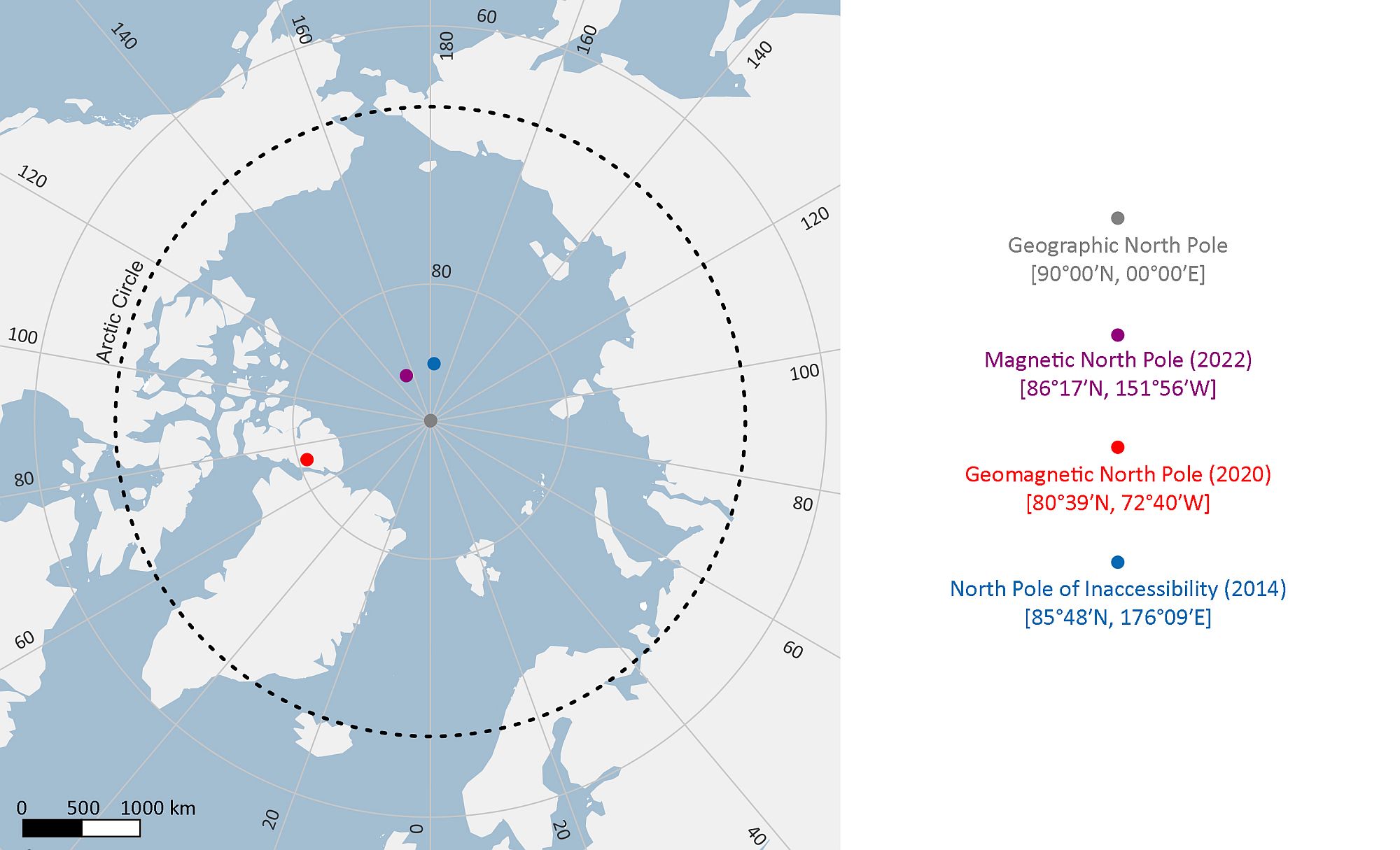
Positions of north poles according to the most recent available data.
Map created by Adam Nawrot on the basis of Natural Earth dataset
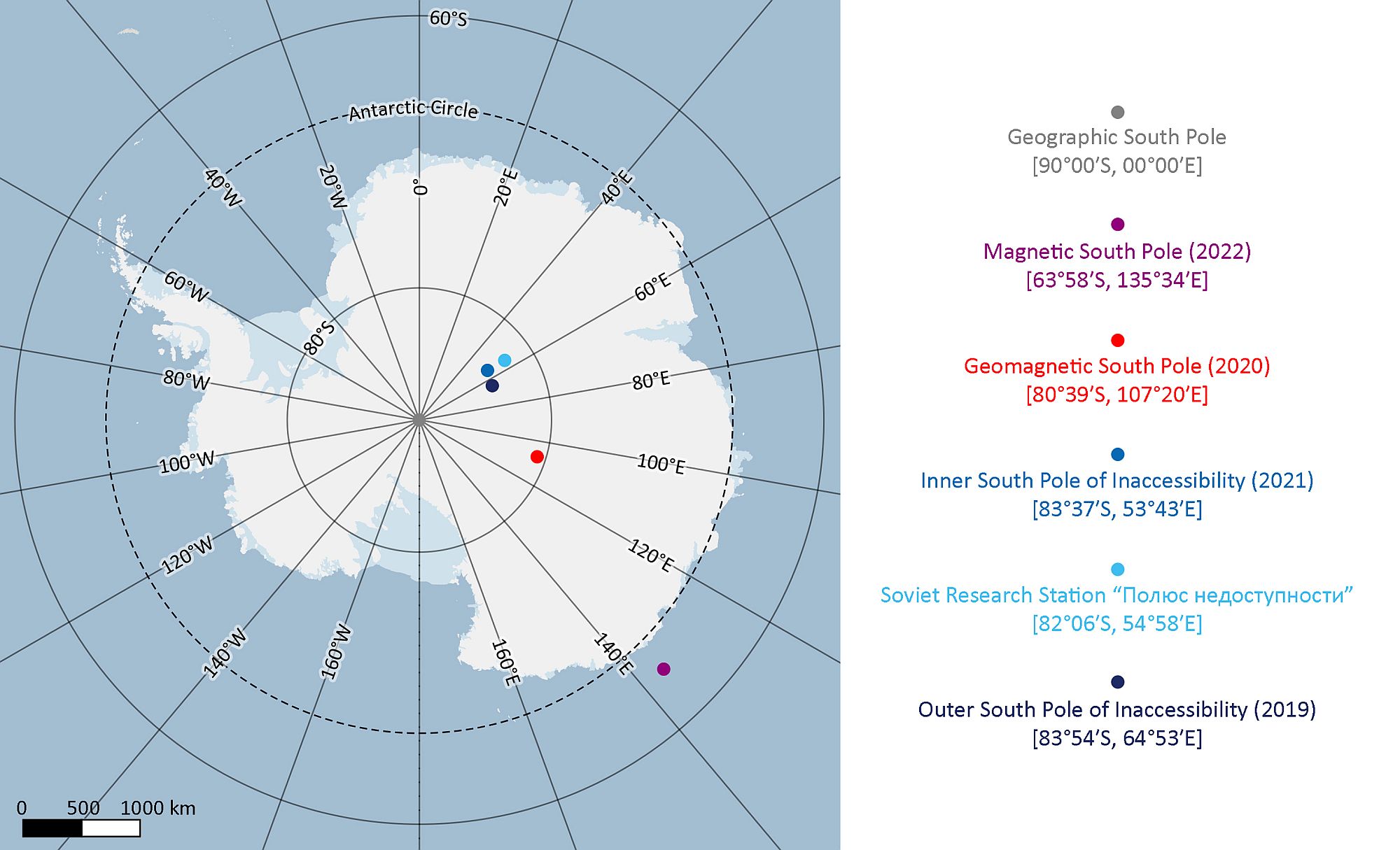
Positions of south poles according to the most recent available data.
Map created by Adam Nawrot on the basis of Quantarctica dataset
Sources:
- Case, N. (2019-05-20) The Earth’s magnetic north pole is shifting rapidly – so what will happen to the northern lights? The Conversation
- Duhaime-Ross, A. (2013) Arctic pole of inaccessibility is on the move. Scientific American
- Feerick, J. (2022-12-28) Earth actually has four North Poles. Discover Magazine: Planet Earth
- Hansen, K. (2022) Ice shelf collapse in East Antarctica [blog post]. NASA Earth Observatory
- Minute Physics (?) Learn about the different types of north poles on the earth – the geographic north pole, the magnetic north pole, and the geomagnetic north pole. Britannica: Video
- National Oceanic and Atmospheric Administration (?) Wandering of the geomagnetic poles [blog post]
- Rajfur, K. (2021-04-26) Dokąd wędrują bieguny? [blog post] Nauka. To lubię
- Rees, G., Gerrish, L., Fox, A., Barnes, R. (2021) Finding Antarctica’s Pole of Inaccessibility. Polar Record, vol. 57(e40), 1–6
- Rees, G., Headland, R., Scambos, T., Haran, T. (2014). Finding the Arctic Pole of Inaccessibility. Polar Record, vol. 50(1), 86–91
- Roots, F. (2017-03-14) Why the North Pole matters: An important history of challenges and global fascination. Canadian Geographic: People & Culture
- Stefansson, V. (1920) The region of maximum inaccessibility in the Arctic. Geographical Review, vol. 10, no. 3, Sep. 1920, 167–172
The article was written as part of EDU-ARCTIC.PL project, funded by the Polish Ministry of Science and Higher Education (DIALOG programme).